


6 multispectral
1.2 million pixels
12bit global shutter
Ethernet port/TTL serial port
On-board real-time reflectance calculation
Standard downlink light sensor (DLS)
≤10W@12V power supply, 64G TF card
Cascading application scene synchronous exposure
Band design continues the composition of mainstream satellite bands
Integrated integration of Skyport interface in cascading application scenarios
| Indicator name | MS600 Dual Indicator Parameters |
| Configuration method | 6 multispectral channels |
| Target size | 1/3″ |
| Effective Pixels | 1.2Mpx |
| shutter type | global |
| quantization bits | 12bit |
| field of view | 49.5°×38.1° |
| ground resolution | 8.65cm@h120m |
| coverage width | 110m×83m@h120m |
| Spectrum channel [1] | 410nm@35nm, 490nm@25nm, 610nm@30nm, 650nm@27nm, 780nm@13nm, 940nm@30nm |
| optical window | Sapphire Optical Glass Window |
| Host size | ≤80mm×75mm×55mm |
| Host weight | ≤280g |
| installation interface | 4 x M3, cascade application Skyport |
| powered by | 12V (For other voltages, please consult Yuchen marketing personnel) |
| power consumption | ≤10W@12V |
| Image Format | 16bit original TIFF & 8bit albedo JPEG (including GPS, ambient light information) |
| video format | — |
| storage medium | Standard 64G, maximum support 128G capacity (transmission speed U3 and above rating) micro SD card |
| processing software | Yusense Map/Yusense Map Plus |
| parameter settings | WIFI (WEB interface access)/UART |
| shooting trigger | External trigger, timing trigger, overlap rate trigger, cascade trigger |
| shooting frequency | 1Hz (related to the actual read and write speed of the storage medium) |
| Working temperature | -10°C~+50°C (relative wind speed ≥1m/s) |
| storage ambient temperature | -30℃~+70℃ |
| environment humidity | RH(%)≤85%(non-condensing) |
| certified product | CE, FCC, RoHS |
typical applicationTypical application
-
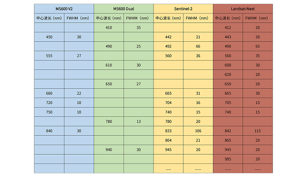
Satellite remote sensing data verificationMS600 Dual and MS600 V2 are cascaded and mounted to form 12-band data acquisition equipment, which is consistent with the current mainstream Sentinel-2, Landsat8 satellite and Landsat-Next satellite spectral band design, ensuring the maximum extent for agriculture, forestry and grass industry, ecological environment and other fields Scientific research scholars unify the information of spaceborne and airborne optocoupler data, which is convenient for carrying out special research such as data verification and information comparison.
-
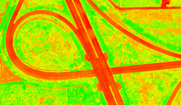
Inversion of vegetation physiological parametersThe MS600 Dual complements the MS600 V2 multispectral camera in the near-infrared band. When used in cascade with the MS600 V2, it can mine more vegetation canopy information, build more spectral factors, and improve the canopy coverage of crops, forests and grasses and other pan-vegetative scenes. Layer physiological parameter inversion accuracy.
-
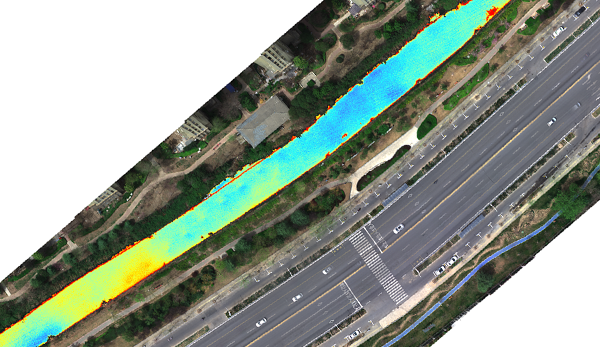
Quantitative inversion of water quality parametersMS600 Dual expands the number of blue-green light bands to provide more refined data information for water body detection, especially for the inversion of parameters such as total nitrogen, total phosphorus, ammonia nitrogen, and COD. Accuracy improvement helps.


")
Reviews
There are no reviews yet.